Proactive water management is no longer an ecological option but a fundamental legal and financial risk mitigation strategy for upstream landowners.
- Altering natural drainage can create significant legal liability for downstream flood damage under established tort law principles.
- Nature-based solutions offer superior long-term cost-effectiveness and ecological co-benefits compared to traditional hard engineering.
Recommendation: Conduct a comprehensive ‘Good Neighbour’ drainage audit to assess your current hydrological liability and implement a landscape-scale plan to slow, store, and filter water on your property.
For landowners and estate managers in upper catchments, the concept of water is shifting. It is no longer a passive element of the landscape but an active agent that carries with it significant, and often underestimated, legal and financial liabilities. The traditional approach of accelerating drainage to quickly move water off the land is being recognized not just as ecologically detrimental, but as a direct cause of downstream flooding, property damage, and potential litigation. This is the core of hydrological liability: the responsibility an upstream landowner holds for the consequences of their water management decisions.
While discussions often centre on generic environmental benefits, the pragmatic reality for a modern estate is one of risk management. The failure to steward the hydrological cycle responsibly can be construed as hydrological negligence. The strategic interventions discussed in this guide—from river re-wiggling to the design of complex wetlands—are therefore not simply ‘green’ initiatives. They are essential tools for due diligence, asset protection, and the mitigation of legal claims. They are investments in resilience that turn a potential liability into a functional, valuable catchment-scale asset.
This guide moves beyond platitudes to provide a framework for action, grounded in legal responsibility and landscape-scale thinking. The objective is to re-evaluate your land as a ‘water battery’—an entity that can be managed to absorb climatic shocks, support ecological function, and, most critically, protect you from the foreseeable consequences of exporting your water problem to others.
To navigate this complex responsibility, this article provides a structured overview of the key principles and practices. The following sections detail the strategic ‘why’ and the practical ‘how’ of managing your catchment’s hydrology to build resilience and mitigate liability.
Summary: Managing the Hydrological Cycle to Prevent Downstream Flooding Liability
- Why Slowing the Flow is Crucial for Catchment Health?
- How to Re-Wiggle Rivers to Restore Natural Hydrology?
- Leaky Dams vs Concrete Weirs: Which is More Cost-Effective?
- The Drainage Mistake That Floods Your Neighbor’s Land
- Scrapes and Ponds: How to Design Wetlands for Maximum Water Storage?
- Riparian Strips vs Engineered Bunds: Which Stops Pollution Better?
- How to Use Infiltration Basins to Direct Clean Runoff Underground?
- Designing Climate-Smart Systems to Buffer Extreme Rainfall Events in the North?
Why Slowing the Flow is Crucial for Catchment Health?
The foundational principle of responsible water stewardship is the deliberate deceleration of water as it moves across the landscape. In a natural, healthy catchment, rainfall does not immediately become runoff. It is intercepted by vegetation, absorbed by porous soils, and stored in wetlands before being slowly released into watercourses. This buffering capacity is what we refer to as the landscape’s ‘water battery’. An unhealthy or poorly managed catchment, characterized by compacted soils and rapid drainage, has a depleted battery. It cannot absorb the shock of a heavy rainfall event, resulting in flashy, high-energy flows that cause erosion on-site and flooding downstream.
Rebuilding this water battery by ‘slowing the flow’ is the single most effective strategy for enhancing catchment health. It is not about stopping water, but about increasing its residence time within the landscape. This simple shift has profound benefits. It reduces flood peaks, mitigates soil erosion, and filters pollutants. Critically, it allows for groundwater recharge, replenishing aquifers that sustain river flows during dry periods. Case studies demonstrate that intensive soil and water conservation can increase dry-season low flows by over 30%, transforming a landscape’s resilience to drought.
From a landowner’s perspective, the economic case is compelling. Investing in natural flood management (NFM) techniques that slow the flow is an investment in the long-term productivity and stability of your land asset. Furthermore, it yields significant returns beyond your own boundary. Current economic analysis suggests that every £1 invested in NFM is expected to deliver £10 of benefits over 30 years, encompassing everything from reduced flood damages to improved water quality and biodiversity. This makes slowing the flow a fiscally prudent, as well as an ecologically sound, management decision.
How to Re-Wiggle Rivers to Restore Natural Hydrology?
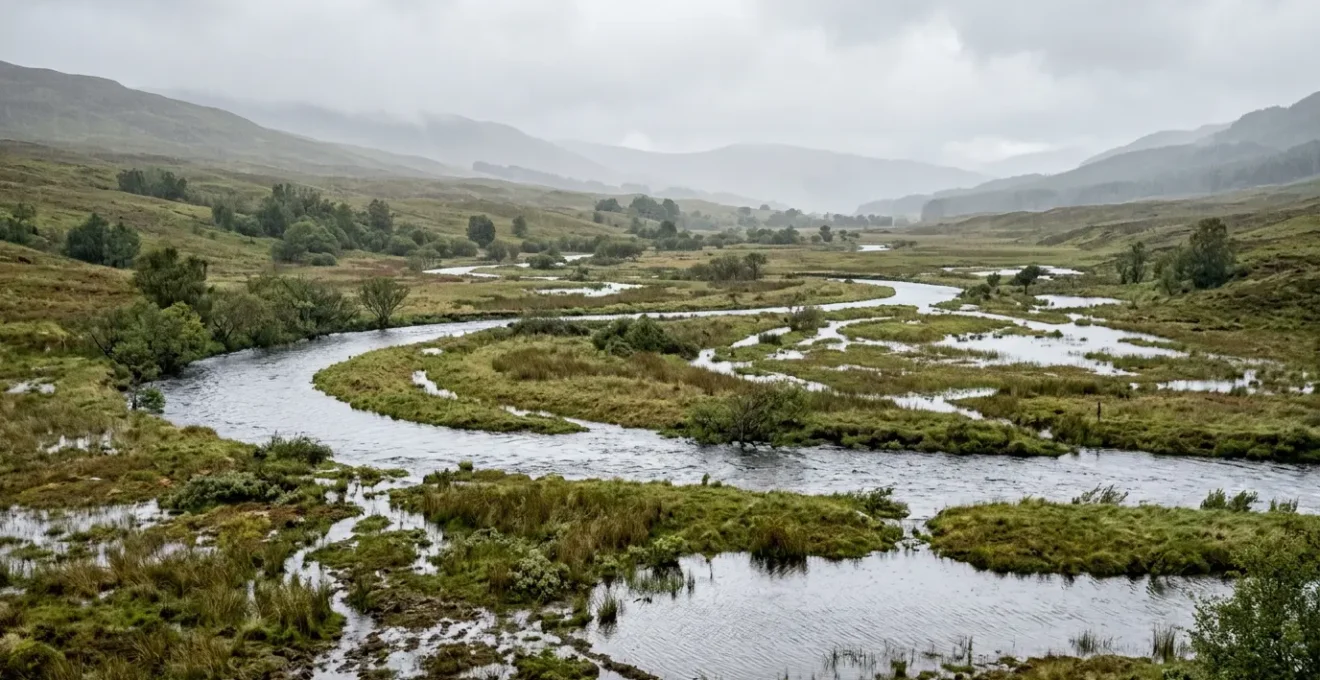
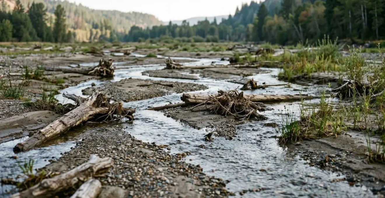
Historically, rivers have been straightened, dredged, and disconnected from their floodplains to ‘improve’ drainage and maximize agricultural land. This has proven to be a catastrophic mistake, turning dynamic ecosystems into sterile, high-energy drainage channels that efficiently export flood risk downstream. Restoring natural hydrology involves reversing this process, a practice often simplified as ‘re-wiggling’ but which encompasses a sophisticated approach to landscape re-engineering known as Stage 0 restoration.
Stage 0 moves beyond simply creating meanders in a single-thread channel. Its objective is to reconnect the river to its entire valley floor, allowing it to form a complex, multi-threaded network of channels, wetlands, and gravel bars. This approach fundamentally changes the river’s energy profile. Instead of concentrating flow and erosive power, it dissipates energy across a wide area. During high flows, the entire valley bottom becomes a functional floodplain, storing vast quantities of water and slowing its progress downstream. This directly addresses a common misconception: that ‘rewilding’ a river increases flood risk. In reality, it dramatically reduces peak flood risk for downstream communities by using the floodplain for its natural purpose.
This process creates an incredibly rich mosaic of habitats. As the image above illustrates, the complex interplay of water and sediment forms a dynamic landscape that supports a vast range of species. A pioneering Stage 0 restoration project on the South Fork McKenzie River documented significant increases in both the area of inundation and the diversity of aquatic life compared to unrestored reaches. For the landowner, this translates into a more resilient, biodiverse, and functional asset that actively works to mitigate flood risk at a landscape scale.
Leaky Dams vs Concrete Weirs: Which is More Cost-Effective?
When considering interventions to slow water flow within smaller tributaries and ditches, landowners are faced with a choice between nature-based solutions like leaky dams and traditional hard-engineered structures like concrete weirs. While a concrete weir offers a sense of permanence and precise hydraulic control, a full analysis of its Total Cost of Ownership (TCO) reveals it to be a far more expensive and higher-risk proposition over the long term. Leaky dams, constructed from natural materials like timber, are designed to be semi-porous, allowing normal flows to pass unimpeded while holding back and slowly releasing water during storm events.
The primary advantage of leaky dams lies in their low cost and ‘graceful failure’ design philosophy. They are inexpensive to install and are intended to shift, settle, and integrate into the ecosystem over time. If a major flood event dislodges a structure, the environmental consequence is minimal, and repairs are straightforward. Conversely, a concrete weir is engineered to a catastrophic failure point. Its failure can release a sudden wave of water and sediment, posing a significant liability. Furthermore, their long-term maintenance and eventual decommissioning costs are substantial.
The following table, based on principles from comparative analyses of nature-based and engineered structures, starkly illustrates the difference in TCO and overall value. Leaky dams not only provide effective flood attenuation for frequent, smaller events but also deliver a suite of ecological co-benefits—such as habitat creation and water quality improvement—that concrete weirs simply cannot.
| Cost Factor | Leaky Dams (Nature-Based) | Concrete Weirs (Engineered) |
|---|---|---|
| Initial Construction Cost | £50-£500 per structure | £10,000-£100,000+ per structure |
| Design Philosophy | Designed to fail gracefully; structures shift and settle, becoming part of ecosystem | Engineered to catastrophic failure; rigid structures pose higher long-term liability risk |
| Long-term Maintenance | Low; periodic inspection, occasional sediment removal, self-repairing through natural processes | High; regular structural integrity assessments, erosion control, mechanical repairs |
| Decommissioning Costs | Minimal; natural materials decompose or remain as habitat features | Massive; concrete removal, site remediation, sediment management |
| Ecological Co-benefits | High value: habitat creation, water quality improvement, biodiversity enhancement, carbon sequestration | Negligible or negative: habitat fragmentation, fish passage barriers, altered flow regimes |
| Flood Attenuation Effectiveness | 10% peak flow reduction for events up to 1-year return period; most effective for frequent smaller events | Higher capacity for large events but no benefit for frequent small events |
| Catchment Scale Application | Upper catchment treatment train; distributed network handling frequent events | Lower catchment protection of critical assets; centralized infrastructure |
The Drainage Mistake That Floods Your Neighbor’s Land
Perhaps the single greatest area of hydrological liability for an upstream landowner is the modification of surface water drainage. The act of concentrating diffuse surface flow into a single pipe, ditch, or channel—and thereby increasing its volume and velocity as it leaves your property—can constitute a form of hydrological negligence. Under the « Natural Flow Rule » or similar legal principles common in many jurisdictions, a landowner is prohibited from altering natural drainage in a way that causes foreseeable harm to their neighbors. If your ‘improved’ drainage system floods an adjacent property, you may be held liable for the damages under tort claims of Nuisance or Negligence.
The mistake is to view drainage solely through the lens of one’s own property, ignoring the interconnectedness of the catchment. Every ditch, culvert, and field drain is a decision that has downstream consequences. As legal experts at FindLaw clarify, this responsibility is not theoretical. As their team states in their legal guide on the matter:
Under the modified rules, you may be able to hold your neighbor liable for damage to your property if the neighbor is negligent in making modifications to their property.
– FindLaw Legal Team, Water Damage and Neighbor Disputes Legal Guide
This principle works both ways. Just as you can be held liable, you may also have recourse if a neighbor’s actions harm you. The key is to act with due diligence and proactively manage your drainage to prevent causing harm. This requires a shift in thinking from water *disposal* to responsible water *conveyance*. Before undertaking any drainage works, a thorough assessment of downstream impacts is not just good practice; it is an essential step in mitigating legal risk. Proactive communication with neighboring landowners and exploring collaborative solutions are also critical components of responsible stewardship.
Your ‘Good Neighbour’ Drainage Audit: A 5-Step Liability Check
- Points of Contact: Map all discharge points and natural flow paths from your land onto neighbouring properties.
- Collect Baseline Data: Document current conditions with dated photographs and measurements before any works are undertaken to establish a baseline.
- Assess for Coherence with Legal Duty: Confront planned alterations with the « Natural Flow Rule » and potential for Nuisance or Negligence claims. Are you concentrating flow unnaturally?
- Evaluate Downstream Impact: Professionally assess how changes in runoff volume and velocity will affect adjacent land and identify potential for harm.
- Plan for Collaboration & Mitigation: Develop a plan for communicating with neighbours and exploring shared solutions (e.g., cross-boundary swales) to mitigate identified impacts.
Scrapes and Ponds: How to Design Wetlands for Maximum Water Storage?
Beyond managing flowing water in rivers and ditches, a key strategy for enhancing a catchment’s ‘water battery’ is the creation of static water storage features like ponds, scrapes, and wetlands. These features act as buffers, capturing runoff during storm events and releasing it slowly over time. However, their effectiveness is not merely a function of their size; it is determined by their design and complexity. A simple, deep, steep-sided pond has limited ecological value and a surprisingly low surface-area-to-volume ratio for interacting with the landscape.
The goal is to design features that maximize water storage and ecological function. This is achieved through creating complex micro-topography. An effective wetland design incorporates a variety of depths, from shallow, ephemeral scrapes (5-10cm deep) that warm quickly and are ideal for invertebrates, to deeper pools (50-80cm) that provide refuge in dry periods. The shoreline should be long and irregular, not a simple circle or square, to maximize the edge habitat where land and water meet. Hummocks and islands within the wetland provide nesting sites for birds and further increase the structural diversity.
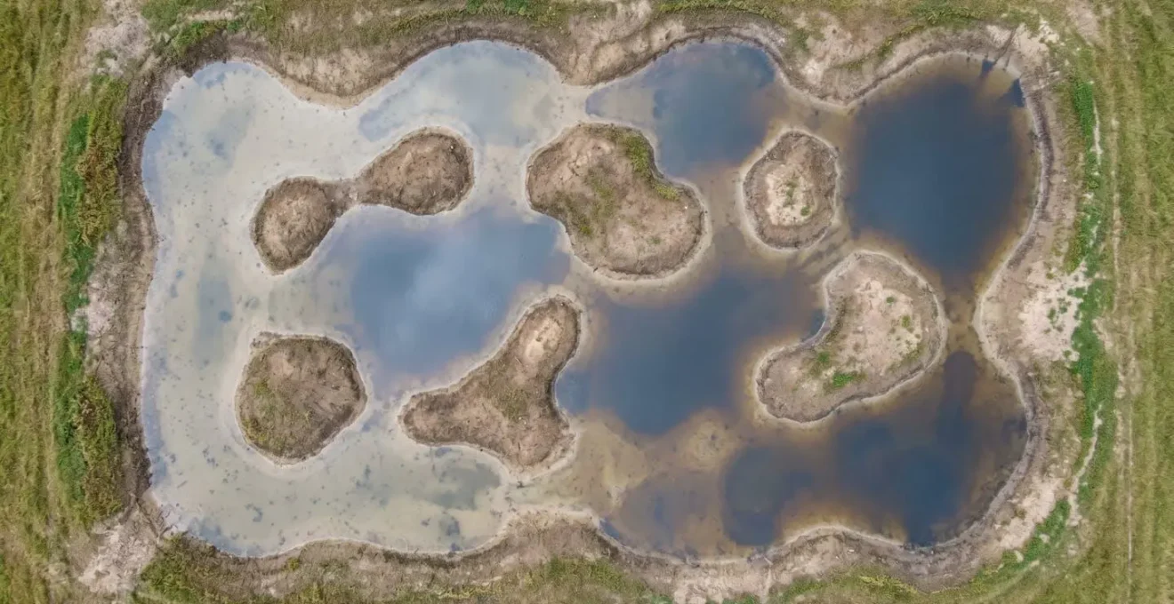
As the overhead view of a well-designed scrape shows, the aim is to create a mosaic of interconnected habitats. This approach not only stores more water per unit area but also creates a system that is far more resilient and biodiverse. In areas with peat soils, the potential is even greater. Restoring peatlands by blocking drainage ditches (grips) can re-hydrate the peat, allowing it to function as a super-sponge. Research shows that healthy peat can store up to 20 times its weight in water, making peatland restoration one of the most powerful NFM tools available for landowners with suitable ground.
Riparian Strips vs Engineered Bunds: Which Stops Pollution Better?
Managing runoff from fields and slopes presents a choice between two primary buffer types: vegetated riparian strips and engineered bunds or swales. Both aim to intercept overland flow, slow it down, and trap sediment and pollutants before they reach a watercourse. However, they function differently and are suited to different landscape contexts. The choice is not a simple « either/or » but a strategic decision based on catchment position and the nature of the runoff.
Riparian strips—wide buffers of grass, trees, and shrubs planted alongside rivers and streams—are most effective at treating diffuse, sheet-flow runoff. The dense vegetation and root systems physically slow the water, allowing sediment to drop out and providing time for infiltration. The value of trees in this context is twofold; not only do their roots stabilize banks, but their canopy also intercepts a significant amount of rainfall before it even hits the ground. Studies indicate that trees can reduce the volume of water reaching the ground by up to 45% for conifers, substantially reducing the initial runoff volume that needs to be managed.
Engineered bunds—low earthwork banks or shallow swales constructed across a slope—are designed to intercept and temporarily store concentrated flow paths. They are a more direct intervention, best placed in ‘critical source areas’ where gullies or hollows channel large volumes of water during storms. While highly effective at capturing coarse sediment and attenuating flow from a specific pathway, they offer less diffuse pollution filtering than a wide, complex riparian zone. The Eddleston Water project in Scotland provided empirical evidence that the most effective approach is a combination of measures, with leaky dams and riparian planting in headwaters and larger-scale features lower down. The key is to match the tool to the problem: strips for sheet flow, bunds for concentrated flow.
How to Use Infiltration Basins to Direct Clean Runoff Underground?
Infiltration basins are a powerful tool for actively recharging your catchment’s ‘water battery’. Unlike ponds or wetlands which are designed to hold water at the surface, an infiltration basin is specifically engineered to get clean runoff back into the ground as efficiently as possible. This technique is particularly valuable in areas with well-draining soils, where it can reduce surface runoff volumes to near zero for moderate rainfall events, replenishing the very groundwater that sustains streams during dry spells.
However, the success of an infiltration basin is entirely dependent on a thorough site investigation. Simply excavating a depression in the ground is a recipe for failure. The most critical factor is the soil’s percolation rate. Standardized ‘perc tests’ are required to confirm that the soil can absorb water at a sufficient rate (typically >13mm/hour). Without this, the basin will simply become a stagnant pond. Equally important is understanding the subsurface geology. Test pits must be dug to ensure there are no impermeable layers like clay or bedrock close to the surface that would prevent vertical infiltration.
Protecting groundwater quality is paramount. A minimum separation of 1.2 to 1.5 meters must be maintained between the floor of the basin and the seasonal high water table. This unsaturated soil zone acts as a natural filter. To prevent the basin from clogging with silt and debris, a sediment forebay is an essential design element. This small, preliminary basin at the inlet captures the majority of suspended solids, which can then be periodically removed, dramatically extending the functional lifespan of the main infiltration area. This technique is suitable only for relatively clean runoff, such as from roofs or low-intensity pastures, and is not appropriate for managing contaminated industrial or heavily polluted urban runoff.
Key takeaways
- Liability is real: Modifying land drainage without due diligence creates a direct legal and financial risk for downstream flood damage.
- Nature-based is cost-effective: Over their full lifecycle, solutions like leaky dams and restored floodplains are significantly cheaper and lower-risk than traditional concrete engineering.
- Design matters: The effectiveness of any intervention, from a wetland to a riparian strip, depends on intelligent design that is appropriate for the specific landscape context.
Designing Climate-Smart Systems to Buffer Extreme Rainfall Events in the North?
The imperative to manage the hydrological cycle is amplified by the increasing frequency and intensity of extreme rainfall events, a trend particularly pronounced in northern latitudes. A landscape’s ability to act as a ‘water battery’ is its primary defence against the shocks of a changing climate. Designing climate-smart systems means creating a distributed network of the interventions we have discussed—restored floodplains, leaky dams, complex wetlands, and infiltration zones—that work in concert to absorb and buffer these extreme events. This is not about a single silver-bullet solution, but about building layered, landscape-scale resilience.
The potential for these systems to mitigate the impacts of extreme rainfall is not theoretical. It has been demonstrated with remarkable clarity. For instance, monitoring data from the River Aller Stage 0 restoration project in the UK shows a 38% reduction in flood peaks and a staggering 1780% increase in groundwater levels, effectively super-charging the landscape’s water battery. This is the ‘return on resilience’: the capacity to weather a storm that would have previously caused catastrophic flooding and erosion.
This approach represents a paradigm shift from defensive, localized flood protection to proactive, catchment-wide flood mitigation. For the upstream landowner, embracing this role as a steward of the hydrological cycle is the most effective long-term strategy. It is an investment that protects your own asset from erosion and soil loss, enhances its ecological and aesthetic value, and, most critically, fulfils your legal and ethical duty to not export flood risk to your downstream neighbours. In an era of climatic uncertainty, building a resilient catchment is the ultimate act of responsible land management.
To begin implementing these principles, the logical next step is to commission a professional hydrological assessment of your estate to identify key risks and opportunities for intervention.