Falling water tables are not just from drought; they are often a direct result of modern farming practices sealing the soil surface, preventing rainfall from reaching the deep reserves your farm depends on.
- Heavy machinery and intensive tillage create an impermeable « cap » that causes winter rain to run off instead of infiltrating.
- Regenerative practices that increase soil organic matter and use diverse cover crops rebuild the « soil sponge, » actively holding and slowly releasing water to the aquifer.
Recommendation: Shift from thinking about isolated recharge projects to whole-farm hydrological management to build true, long-term water resilience from the soil up.
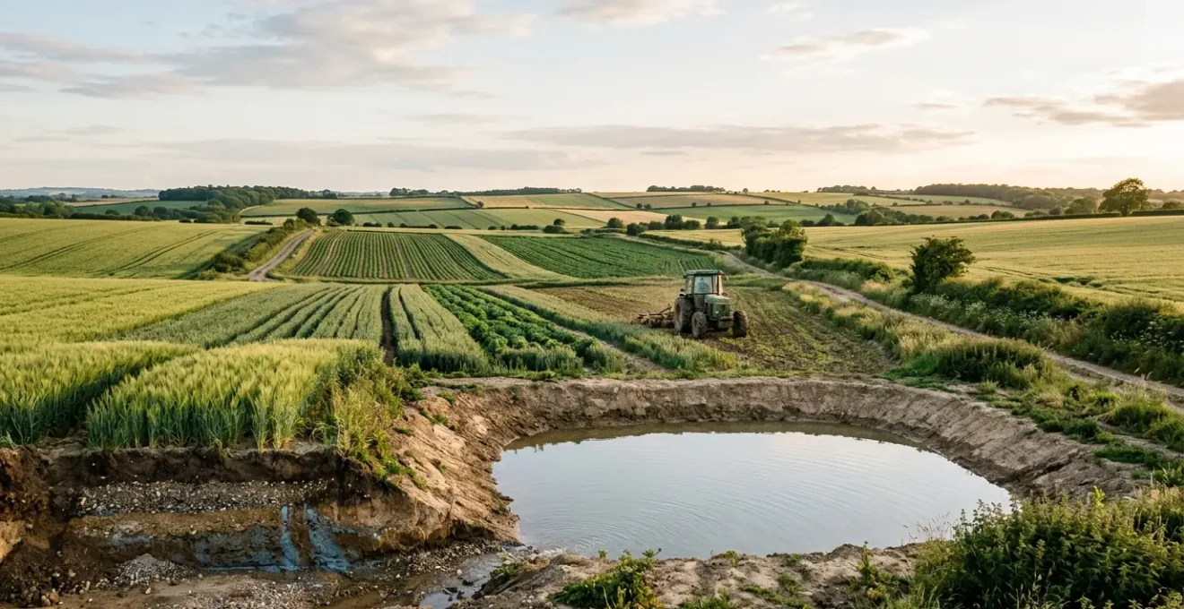
For farmers in water-stressed regions, the level of a borehole is more than a measurement; it’s a direct indicator of economic viability and future security. The sinking feeling that comes with a sputtering pump is a tangible fear, often attributed solely to shifting weather patterns or increased irrigation. While these are factors, they overlook a more fundamental problem forged over decades of industrial agriculture: the very ground beneath our feet has been inadvertently sealed. We have created an artificial barrier between the sky and the ancient water reserves we so desperately need to replenish.
The conventional response often involves engineering: drill deeper, build a bigger reservoir. But this is a race to the bottom. The true, sustainable solution lies not in fighting for the last drops of a finite resource, but in reactivating the natural, geological pathways that allow aquifers to breathe and recharge. This requires a shift in perspective, viewing your farm not as a surface for production, but as a living, porous membrane—a ‘slow-water sponge’—that is the primary infrastructure for your water security.
This guide moves beyond surface-level fixes. We will dissect the problem of soil capping and explore a suite of techniques designed to transform your land into an active agent of groundwater replenishment. From the biology of cover crops to the physics of soil organic matter and the strategic design of landscape features, you will learn how to manage your farm’s entire hydrological cycle. The goal is to build a system that not only captures winter rains but also cleans, stores, and slowly percolates that water back into the deep-time reserves that will sustain your operation for generations.
This article provides a detailed roadmap for farmers ready to take control of their water destiny. The following sections break down the core principles and actionable strategies for turning your land into a powerful tool for aquifer recharge.
Contents: A Farmer’s Guide to Aquifer Recharge
- Why Soil Capping Prevents Winter Rains from Reaching the Aquifer?
- How to Use Infiltration Basins to Direct Clean Runoff Underground?
- Forest vs Arable: Which Land Use Allows More Recharge?
- The Chemical Spill Mistake That Contaminates Aquifers for Decades
- Winter Cover Crops: How They Help Clean Water Before It Percolates?
- Why 1% More Organic Matter Holds 20,000 Gallons of Water?
- Scrapes and Ponds: How to Design Wetlands for Maximum Water Storage?
- Managing the Hydrological Cycle to Prevent Downstream Flooding Liability?
Why Soil Capping Prevents Winter Rains from Reaching the Aquifer?
From a hydrogeological perspective, a healthy soil profile is a complex network of pores, root channels, and biological pathways that acts as a gateway to the aquifer below. However, decades of conventional farming, particularly the repeated use of heavy machinery on wet ground, have systematically destroyed this structure. This process, known as soil capping or compaction, effectively creates an impermeable layer just below the surface. When winter rains arrive, instead of soaking in, the water hits this seal and is forced to move laterally as surface runoff, taking valuable topsoil with it and failing to replenish the groundwater.
The impact is not trivial. Research shows that the pressure exerted by agricultural machinery reduces water infiltration rates by up to 80% compared to uncompacted soil. This means that for every 100mm of rain that falls, as little as 20mm may begin the slow journey to the aquifer, while the rest is lost. This ‘capping’ effect is the single greatest bottleneck in the natural recharge cycle on many farms. It disconnects the atmospheric water supply from the geological water storage, leaving boreholes to decline even in years with seemingly adequate rainfall.
Case Study: Reversing Compaction at Brown’s Ranch
Gabe Brown’s transition to no-till farming in North Dakota offers a powerful demonstration of reversing this damage. Over 16 years, his farm’s soil organic matter doubled, and the biological activity flourished. The result? Enhanced soil structure with extensive worm pathways that now allow water to percolate deep into the profile. During one significant weather event, the farm was able to absorb 8 inches of a 12-inch rainstorm before any runoff occurred, directly showcasing the reversal of the compaction penalty and the reactivation of deep infiltration pathways.
Breaking this cycle requires a fundamental shift from tillage, which provides a short-term fix but ultimately exacerbates compaction, to practices that rebuild the soil’s living architecture. The first step in replenishing an aquifer is to reopen the front door by de-capping the soil.
How to Use Infiltration Basins to Direct Clean Runoff Underground?
While restoring soil health across the entire farm is the ultimate goal, targeted engineering can significantly accelerate aquifer recharge. Infiltration basins are purpose-built depressions in the landscape designed to capture surface runoff and hold it long enough for it to percolate down into the underlying aquifer. Unlike a simple farm pond lined to hold water, an infiltration basin is designed for leakage. It is a strategic tool for directing clean runoff—from roofs, tracks, or less-absorbent fields—to areas with high infiltration potential.
The key to a successful basin is careful site selection and design. The location must have a direct hydraulic connection to the unconfined aquifer you wish to recharge, meaning no impermeable clay layers are present in the vadose zone (the unsaturated earth between the surface and the water table). The design must also account for maintenance. Over time, the bottom of the basin can become clogged with fine sediments and algal growth, creating a new ‘cap’ that seals the surface. A well-designed system includes a protocol for periodic drying and scraping to maintain high infiltration rates.
These basins are not just holes in the ground; they are managed hydrological assets. They represent a more active approach to water management, turning what would be lost runoff into a direct deposit into your farm’s subterranean water bank. When properly sited and maintained, they are a powerful component of a whole-farm water strategy.
Action Plan: Key Steps for Siting and Designing an Infiltration Basin
- Verify Aquifer Access: Before any construction, ensure no impermeable layers are present below the intended recharge area that would block percolation.
- Design the Retention Structure: Construct the basin using earthen banks or by excavating into the ground to create the required footprint for holding runoff.
- Minimize Surface Compaction: Keep machinery traffic to an absolute minimum during and after construction to preserve the natural permeability of the vadose zone.
- Plan a Maintenance Protocol: Implement a schedule for periodic drying and scraping of clogged surface layers caused by suspended solids and algal biofilm growth.
- Size the Basin Appropriately: Ensure the basin is large enough to handle peak flows and prevent flooding. While larger basins may have higher land acquisition costs, they are often cheaper to operate long-term.
Forest vs Arable: Which Land Use Allows More Recharge?
The contrast between a dense, ancient forest floor and a tilled agricultural field provides a stark lesson in hydrology. A natural forest ecosystem is the gold standard for aquifer recharge. Its multi-layered canopy intercepts rainfall, reducing the erosive force of droplets, while the deep, undisturbed soil—rich in organic matter, fungal networks, and root channels—acts like a vast sponge. The bulk density is low, and the hydraulic conductivity is high, meaning water can move through it with minimal resistance.
In contrast, conventional arable land often suffers from high bulk density due to compaction. The soil structure is repeatedly pulverised by tillage, destroying the natural pores and pathways that water needs. The result is a dramatic reduction in infiltration capacity. This is not a matter of opinion but of measurable physics. Data clearly shows the profound difference in how soil behaves under different management regimes.
The following table, based on soil science research, compares key hydraulic properties across different land use types, illustrating the severe penalty that compaction imposes on water infiltration.
As this comparative analysis of soil properties shows, the path to better recharge involves mimicking the characteristics of a forest floor.
| Land Management Type | Bulk Density (g/cm³) | Hydraulic Conductivity (cm/hr) | Infiltration Rate (cm/hr) |
|---|---|---|---|
| Natural Forest Soil | 0.95 | 35.49 | 7.21 |
| Non-compacted Grassland | ~1.20 | Variable (4-5x compacted) | 4-5x higher than compacted |
| Compacted Agricultural (Tractor) | 1.87 | 0.69 | 0.00 (severely compacted) |
| Agricultural Vertisols (Tilled) | Higher than forest | Lower than forest | 275.8 mm/h (final rate) |
| Non-agricultural Leptosols | Lower than ag | Higher than ag | 2210.6 mm/h (final rate) |
This doesn’t mean a farmer must abandon productive land to forestry. Instead, it points towards hybrid systems like agroforestry and silvopasture, where rows of trees are integrated into cropland or grazing systems. These trees act as ‘recharge pumps,’ creating zones of high infiltration that benefit the entire field, proving that productivity and hydrological function can coexist.
The Chemical Spill Mistake That Contaminates Aquifers for Decades
Actively promoting aquifer recharge comes with a profound responsibility: ensuring the water being sent underground is clean. An infiltration basin or a highly permeable field can just as easily funnel contaminants into an aquifer as it can clean water. Once an aquifer is contaminated with persistent chemicals, such as pesticides, nitrates, or industrial solvents, remediation is extraordinarily difficult, expensive, and can take decades, if not centuries. This is the single most critical risk in any managed recharge project.
The most common mistake is assuming that soil will act as a perfect filter. While healthy soil has remarkable filtering capabilities, it is not infallible. A sudden, concentrated chemical spill or the long-term, low-level leaching of agrochemicals can overwhelm the soil’s capacity to break them down. The risk is magnified if the vadose zone—the layer of earth between the surface and the water table—contains pre-existing pockets of contamination. Infiltrating water can mobilize these dormant chemicals, creating a pollution plume that spreads through the aquifer.
As the Interstate Technology & Regulatory Council (ITRC) warns in its guidance on managed aquifer recharge, prior assessment is non-negotiable. Their experts state:
It is also important to make sure the vadose zone does not contain undesirable chemicals or contaminants that could leach into the receiving aquifer.
– Interstate Technology & Regulatory Council, Managed Aquifer Recharge Guidance – Infiltration Basin Fact Sheet
Best Practice: Orange County’s Water Quality Fail-Safe
Orange County’s large-scale managed aquifer recharge program in California provides a model for responsible water management. To prevent contamination, they employ extensive pre-treatment systems, including riverbed filtration, to remove suspended solids and other impurities *before* the water ever enters the dedicated infiltration basins. This approach acknowledges that the basins are primarily for infiltration, not treatment, and builds in fail-safes to protect the long-term integrity of their vital groundwater supply.
The principle is simple: never infiltrate water of a lower quality than the receiving aquifer. This requires rigorous source control, buffer strips around recharge zones, and a deep understanding of the land’s history to avoid inadvertently causing a multi-generational environmental problem.
Winter Cover Crops: How They Help Clean Water Before It Percolates?
Leaving fields bare over winter is a missed hydrological opportunity. Winter cover crops are not just for preventing erosion or fixing nitrogen; they are a living, active tool for water management. A diverse cocktail of cover crops transforms a dormant field into a dynamic filtration and infiltration system, preparing the ground to receive and process winter rains long before the cash crop is planted.
The mechanism is twofold. First, the dense canopy and root mass slow down surface runoff, giving water more time to soak in. Second, and more importantly, the roots create a network of macropores that act as conduits, channeling water past the compacted near-surface layer. Species like tillage radishes have powerful taproots that can drill down through compacted pans, creating deep channels that remain even after the plant terminates. Meanwhile, the fibrous root systems of grasses like winter rye create a fine, web-like structure in the topsoil, enhancing aggregation and porosity.
Furthermore, this biological activity helps to ‘clean’ the water as it percolates. The active microbial community in the rhizosphere (the area around the roots) can metabolize and break down residual nitrates and other agrochemicals, reducing the nutrient load that reaches the groundwater. The practice has become so recognized for its environmental benefits that it is now a cornerstone of publicly funded conservation programs. In the US, for instance, a recent USDA Office of Inspector General report noted that cover crops were the top funded practice in FY 2022, representing over $400 million in investment.
Case Study: The Multi-Species Cocktail at Stoneyvale Farm
In Maine, dairy farmers Bob and Travis Fogler use a diverse, multi-species cover crop cocktail on their 750+ acres. Their mix includes annual rye, triticale, tillage radish, turnip, and crimson clover. This blend is a perfect example of a ‘cocktail strategy’: the deep-rooting radishes break up compaction, the nitrogen-scavenging rye mops up excess nutrients, and the clover fixes atmospheric nitrogen for the next crop. This approach maximizes both water filtration and soil health goals, creating a thick, protective mulch when terminated in the spring.
By keeping the soil biologically active year-round, cover crops are one of the most effective and low-cost ways a farmer can prepare their land to absorb and filter every possible drop of winter rain.
Why 1% More Organic Matter Holds 20,000 Gallons of Water?
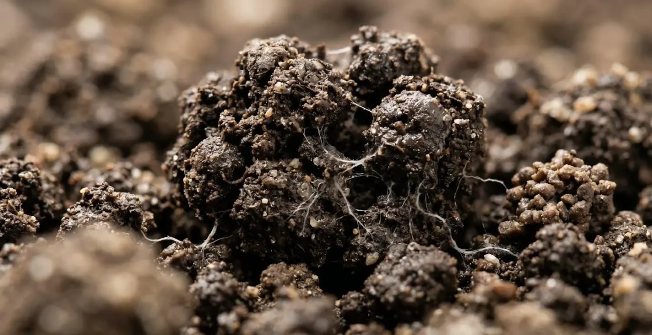
The assertion that a 1% increase in soil organic matter (SOM) can help an acre of soil hold an additional 20,000 gallons of water is a cornerstone of the soil health movement. To a hydrogeologist, this isn’t magic; it’s a function of physics and biology. Soil organic matter, the dark, carbon-rich component derived from decomposed plants and organisms, acts like a microscopic sponge. It has a vast surface area and a porous structure that can adsorb and hold many times its own weight in water.
This « sponge effect » dramatically changes a soil’s water-holding capacity. It creates stable soil aggregates, which are clumps of soil particles bound together by biological glues from bacteria and fungal hyphae. The spaces between these aggregates (macropores) allow water to infiltrate quickly during a storm, while the tiny spaces within the aggregates (micropores) hold onto that water, releasing it slowly to plant roots and, eventually, to the deeper soil profile. This is the mechanism that prevents both drought and runoff. For context, according to Ohio State University Extension research, a single acre-inch of water is approximately 27,000 gallons, making the 20,000-gallon figure for each percentage point of SOM a highly significant volume.
Increasing SOM is a long-term project achieved through practices like no-till, cover cropping, and integrating livestock. It’s about systematically adding carbon to the soil year after year. The result is a fundamental transformation of the land from an inert mineral medium into a living, breathing hydrological asset.
Case Study: The ‘Living Sponge’ Effect at Brown’s Ranch
The transformation at Gabe Brown’s North Dakota farm provides a powerful real-world example. By increasing his soil organic matter from around 1.8% to over 4.2%, he fundamentally changed his farm’s relationship with water. The increased SOM, fostered by a rich diversity of soil biology including mycorrhizal fungi, created incredibly stable soil aggregates. This was demonstrated when the farm absorbed 8 inches of a 12-inch downpour before any runoff was observed, illustrating the immense water-holding capacity of a high-carbon, living soil system.
This is the essence of building water resilience from the ground up. By focusing on building soil carbon, a farmer is simultaneously building a water reservoir directly beneath their feet.
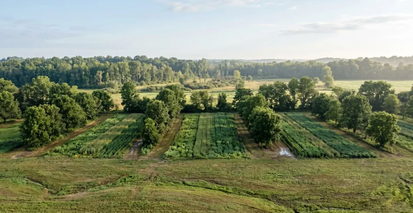
Scrapes and Ponds: How to Design Wetlands for Maximum Water Storage?
Moving from the soil profile to the landscape scale, strategically designed ponds, scrapes, and wetlands are critical tools for managing large volumes of water. However, for the purpose of aquifer recharge, not all ponds are created equal. The goal is not permanent storage but temporary retention to maximize infiltration. This requires a different design philosophy, one that prioritizes surface area, slow flow, and a leaky bottom over depth and water-tightness.
An effective design often involves creating a ‘treatment train’ or a series of interconnected, terraced basins rather than one large pond. This slows the water’s momentum, allowing more sediment to drop out in the upper ponds and giving cleaner water in the lower ponds more time to infiltrate. The sizing of these basins involves a trade-off: larger basins may be more expensive in terms of land use but are often cheaper to operate and maintain in the long run. The scale of such projects can be immense; for instance, analysis of California’s response to groundwater overdraft shows plans for over 2.5 million acre-feet of Managed Aquifer Recharge (MAR) annually.
As with smaller infiltration basins, clogging is a major long-term challenge. A proactive maintenance plan for removing sediment and managing algal growth is essential. However, these features can be designed for multiple benefits beyond just recharge. They can serve as invaluable wildlife habitats, sediment traps that protect downstream water quality, and even a source of water for irrigation or fire suppression, creating a stacked set of ecological and economic benefits for the farm.
Action Plan: Wetland Design Principles for Aquifer Recharge
- Design Interconnected Series: Create wetland ‘trains’ with multiple smaller, terraced basins to slow water flow and maximize infiltration time.
- Optimize Basin Sizing: Balance the upfront land acquisition costs of larger basins against their long-term operational efficiency and lower maintenance needs.
- Manage Clogging Proactively: Implement maintenance protocols that include periodic drying and scraping of surface layers to remove performance-inhibiting sediments and biofilms.
- Stack Ecological Benefits: Position basins to serve multiple functions, such as sediment trapping, creating wildlife habitat, and potentially treating farm wastewater.
- Ensure Aquifer Compatibility: Verify the vadose zone is free of legacy contaminants and that no impermeable layers exist that would block percolation to the target aquifer.
By viewing these water features as dynamic systems rather than static ponds, a farmer can integrate them into the landscape as powerful engines of aquifer replenishment.
Key Takeaways
- Soil compaction is the primary barrier preventing rainfall from recharging aquifers on agricultural land.
- Increasing soil organic matter is the most effective way to build a ‘soil sponge’ that captures, holds, and slowly releases water.
- A combination of in-field practices (cover crops, no-till) and landscape engineering (infiltration basins, wetlands) creates a resilient, whole-farm water management system.
Managing the Hydrological Cycle to Prevent Downstream Flooding Liability?
A farmer’s influence on water does not end at their property line. The way a farm manages its rainfall has direct consequences for the entire watershed, including downstream communities and ecosystems. A farm with compacted, capped soils acts like a paved parking lot, accelerating runoff and contributing to flash flooding downstream. This is increasingly becoming a source of legal and social liability for landowners. Conversely, a farm managed as a ‘slow-water sponge’ provides a vital public service by holding back peak flows, reducing flood risk for everyone.
This shift in perspective—from water disposal to water retention—is opening up new collaborative models and even potential revenue streams. The concept of ‘peak flow credits’ is emerging, where upstream landowners could be compensated for implementing practices that provide a measurable flood mitigation service to downstream municipalities or water users. This reframes regenerative agriculture not just as an environmental practice, but as a form of green infrastructure with quantifiable economic value for the wider community.
This systemic view requires collaboration. Watershed-level partnerships between farmers, conservation districts, and water management agencies are proving to be the most effective way to tackle large-scale water challenges like aquifer overdraft and flooding.
Case Study: Pajaro Valley’s Cooperative Recharge Program
The Pajaro Valley Recharge Net Metering (ReNEM) program in California is a pioneering example of this collaborative approach. It brings together private landowners, a Resource Conservation District, the local water management agency, and university researchers. Landowners who install and operate approved aquifer recharge systems receive rebates on their water bills based on the volume of water they successfully infiltrate. This system helps offset their operational costs while directly contributing to addressing the valley’s 12,100 acre-feet of annual groundwater overdraft. It is a working model of how to incentivize and coordinate private land stewardship for public watershed benefit.
By embracing the role of a hydrological manager, a farmer can transform a potential liability into a community asset, strengthening their social license to operate while building a more resilient and profitable farm.
The logical next step is to begin assessing your own farm’s hydrological function. Start by observing where water flows and pools during heavy rain, digging test pits to examine soil structure, and considering which of these strategies could be implemented to begin the long but rewarding process of rebuilding your land’s connection to the ancient water reserves below.